
Onto Oregon
July 29, 2020
We finally made it to Oregon!
Oregon is one of the states I was most excited to visit on our American tour. When I was researching activities to do around the country before we left on our journey, Oregon was one of the most dog-friendly places with lots of picturesque hikes.
Crater Lake National Park
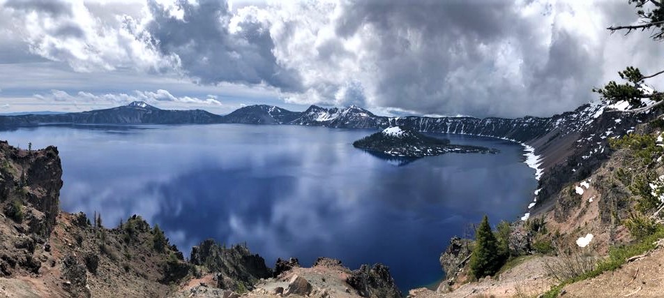
Our first stop in Oregon was Crater Lake National Park. I had wanted to do the Cleetwood Cove Trail and take a ferry out to Wizard Island but most of the trails there were still closed there due to snow in June. The park only even officially opened June 8th. Mind-blowing to two Houstonians accustomed to hibernating in the AC by this time of year.

This park isn’t dog-friendly, so we settled on driving around the West Scenic Rim Drive (the East Rim was also still closed due to snow) and stopping at all of the overlooks along the way.


Crater Lake is the result of a volcanic eruption that triggered the collapse of its tall peak thousands of years ago. Every overlook around the scenic rim offers a different view of Wizard Island, a smaller volcano within the crater.


Its bright blue waters are extremely pure: fed only by rain and snow. It is the deepest lake in the USA.


Our favorite overlook was Merriam Point, close to the West Entrance.

Interactive photo – click and drag to look around:


Watson Falls
Oregon is the place to go if you want to see waterfalls. And our first one, Watson Falls, may still be my favorite we’ve seen. It’s a short but magical 1-mile hike. From the first step it felt like we were waltzing into a fairytale; the path follows a bubbling stream past rocks covered in neon peat moss and lush green ferns under the shade of tree canopies.


Watson Falls has a 293-ft drop and is the tallest waterfall in Southwest Oregon.


There’s a viewpoint at the bottom, and if you climb up further, there’s another viewing area closer to the top of the falls.


We actually only happened upon Watson Falls after finding that it was just down the road from Toketee Falls which had been on “my list” since the beginning. I discovered they were so close together using my free AllTrails app (in map mode). We use AllTrails constantly. I’d highly recommend it to anyone who enjoys hiking, camping, RVing, or even anyone who just wants to find short walks near their home that they may not have known existed!
Toketee Falls

The very same day we visited Toketee Falls. “Toketee” is a Chinook word meaning “pretty”, and that they are.

At the start of the trail, there is an impressive redwood-stave flowline made out of wood, completed in 1949. It is 12-ft in diameter. The water powers three generator turbines that have a capacity of 45 megawatts of electricity, enough energy for ~22,500 homes.


The walls of Toketee Falls are basaltic lava columns which originated from Mount Bailey volcano.

I think there might be another trail that takes you down below, in front of Toketee falls, but the 1-mile trail we took led to a viewing platform overlooking the falls.

Tumalo Falls
Remember when we were back in the Sedona area and I told you to prepare yourselves for more and more red rocks? Well settle in, because we’ve entered a reminiscent sequel about waterfalls.

For whatever reason, the main gate was closed so we had to hike an extra couple of miles just to get to the Tumalo Falls trailhead.

Then we hiked up to an overlook at the top of Tumalo Falls.


Painted Hills

At the Painted Hills in John Day Fossil Beds National Monument we first hiked the 1.6-mi Carroll Rim Trail.


Next we strolled the relatively flat 0.6-mi Painted Hills Overlook, where a sign helpfully reminded us to socially distance from people and to leave a much larger distance between us and any bears.


Smith Rock State Park

Smith Rock State Park reminded me of Zion with tall rock cliffs jutting up around a river running through its center.

We originally set out to hike the Misery Ridge and Mesa Verde Trail before discovering about halfway in that AllTrails expected us to full-on rock climb to the other side of the cliffs on this particular “trail”. Since we had left our rope and harnesses at home (just kidding, there’s not enough rope in the world to help us hoist this basset hound over any cliffs), we hopped on the Crooked River Trail somewhere in the middle instead.

We returned to our boondocking spot on public land where we had no cell phone service or WiFi. But we did have what I termed Animal Planet Live:
These free range cows had a routine and usually circled by our place in the early afternoon. We referred to them as the neighbors.
“The neighbors are here!” “Bruno, did you say hi to the neighbors?”

It was all good and fun until on the last day one of the calves started incessantly screaming. I’m not exaggerating. Have you heard a cow scream? I hadn’t either, but there’s no other way it could possibly be described. He was just hanging out with all of the other cows behind the trailer while they quietly mowed our lawn, and he would randomly scream. We imagined the other cows saying “Ugh, Dave, what is wrong with you?! Shut up!”
The cows eventually moved on to wherever the cows go, but the screams could be heard into the darkness of the night. The next day we got the heck out of that horror moooovie of a place. We wished the neighbors well on our way out and asked them to please check on Dave and get him some help.
Sahalie Falls

Sahalie Falls was a last-minute hike as we intended to go to the Tamolitch Blue Pool but the short path to the overlook was closed and we didn’t feel up to a long hike that morning. But what is this trip about if not spontaneity? So we ventured to the nearby Sahalie Falls and were greeted by a rainbow over the falls.

The main viewpoint of the falls is just steps from the parking lot. There’s a nice little pool at the top too where the icy water makes it feel air conditioned. It’d be nice to just go hang out there with a cold beer on a hot day.

We decided to go a little further and crossed a small bridge over the stream feeding the falls to have a look at it from the other side as well. As it turns out, the nice little pool mentioned above is actually the top of the smaller waterfall on the right.


Proxy Falls

Proxy Falls Loop is a 1.6-mi trail that winds through open lava rock fields to a gorgeous moss-covered waterfall.


The icy spray from the waterfall was very refreshing on this hot day. We sat at a distance for a while and enjoyed the cooling effect on the air. We only left when I actually started to get too cold.


When we don’t go chasing waterfalls, Sean continues baking bread (he’s also tried his hand at kolaches and english muffins) and I’ve been doing a little painting with alcohol inks.

Pretty photos as usual! And love the paintings, Chelsea!
Dying at Dave hahahah
Hoisting a Basset over cliffs! Animal Planet Live! Horror Moooovie! Dave! Where’s the laughing emoji when you need it?! Spectacular photos as usual and I love your art work! Hoping Santa might manage to bring me a dark blue or grey one?? ; ) Your waterfall photos reminded us of Iceland–so pretty! Several people have told me they can hear me in your humor….not sure if that’s good or bad. Stay safe and keep being spontaneous! <3
OMG Chelsea! I’ve read all your blogs and am so impressed with your travels! (And a bit jealous 😎)
Our bucket list continues to grow as we watch your adventures! Drake did a few months out west for Mountain Classroom last year, now taking time off from college to do the Appalachian Trail next spring. Keep up the great documentary & be safe! Trudy & Steve Leask