
Less-Crowded Trails in the Sedona Area: Part Two
May 13, 2020
Alternate title: Are you tired of Arizona yet?
Second alternate title: Don’t worry, we’re heading to another state
Third alternate title: It’s not my fault there’s so much to do here
If you’re bored of pictures of red rocks, I apologize. But I’m still not tired of looking at red rocks… this place is freaking beautiful. However it’s starting to get hot here, so we’re going to make like the birds and fly north. I’m not not getting paid just to stay in one state all year.
But if you aren’t bored yet, this post contains our last hikes in the Sedona area. So read on…
Fay Canyon & Fay Arch

On a particularly sizzling day, we decided to hike the Fay Canyon Trail, because the path to the canyon is shaded by tree canopies and the canyon itself has lots of shaded nooks.
Interactive photo – click a drag to look around:
We found a nice, cool spot for lunch and felt like we had the whole canyon to ourselves.


After lunch, we ventured further into the canyon on a path that wasn’t so much a trail but that made us feel like real explorers. Bruno used his nose to show us the way when we weren’t quite sure where to go next.

By the time we got back to the bottom of the canyon, things were starting to get too crowded for my comfort so we hurried back under the trees to an offshoot trail leading to Fay Arch.
It’s hard to get a good shot of Fay Arch because there’s not much contrast between the sandstone rock behind it and the arch itself. But if you look hard, you can see it here:

We climbed up and hung out under the arch.


The lighting was pretty neat underneath the arch in the early afternoon.

Watson Lake

Watson Lake was another place on my list of Top Underrated Spots in Arizona that I was particularly excited to visit. Again, technically not in Sedona, but nearby in Prescott, AZ.
I know I advertised lots more red rocks in this post, but Watson Lake is actually characterized by large granite boulders jutting up from its shorelines and as tiny islands.
We took the 5-mile Watson Lake Loop Trail around its perimeter which is half climbing up and down the round boulders around Watson Lake and half flat path around the sister Willow Lake.


We also circled the back of the dam on this trail.


The dogs were totally exhausted after hiking all morning, so we ate lunch in the refreshing AC and shade of our truck. But we couldn’t leave this beautiful lake without getting in the water! So we blew up our inflatable kayaks, strapped on the doggie life vests, and paddled out from a small boat ramp.


After a while the dogs just couldn’t handle anymore adventure and let the waves rock them to sleep. Luckily the inflatable kayaks double as excellent pillows.


I decided to try to be a “real” blogger and add affiliate links, at least for the things I’d normally provide links for anyway. As an Amazon Associate I earn from qualifying purchases (made via the links on our blog). Paul, don’t you think these could come in handy during hurricane season? 😉
Airport Loop
For our the final hike on our last day in the Sedona area, we hiked the 3.2-mile Airport Loop trail that wraps around the Sedona airport which is set on a hill.

As you can imagine if you know Sean (he has his pilot’s license and acts like a kid on Christmas every time he spots an airplane), this was a perfect hike for him. As you hike clockwise around the airport, there are red rock views to your left and occasionally airplanes fly overhead to land at the airport to your right.


After that last hike, we finally packed up the RV to head north. We enjoyed our month-long stay in Rimrock, AZ. We saved some money, had plenty to do nearby, and had some extra security during this pandemic chaos. At this point though, we feel pretty confident that we’ll be able to safely find places to stay as we journey onward.
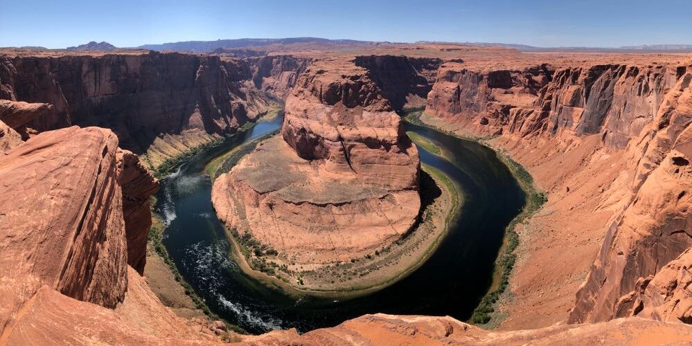
Horseshoe Bend

Near Page, AZ, there is a short 1.5-mile out-and-back trail from a parking lot to the Horseshoe Bend overlook. Lucky for us, Arizona is currently waiving fees to visit! So we parked the RV in the fairly empty parking lot and trekked out to see this iconic Arizona landmark.

This spot had been on “my list” from the start so I was pretty jazzed to be getting this roadtrip back on track.
Interactive photo – click a drag to look around:


That night, we set up for the first of many nights of boondocking (setting up without electric/water/sewer connections; for free; usually on public land). First stop: Glen Forest National Recreation Area. We bumped along down a long dirt road with high rocks all around us.
The moon and stars were so bright, we didn’t need flashlights to let the dogs out at night where they could run around without a soul in sight and really feel like the world was their toilet.

Spoiler: we would spend the next week or so boondocking with very poor wifi/cell reception, and thus I am very far behind on this blog. We have finally made it back to civilization and cell phone service in Utah. I am hoping to do another post sooner than usual to get you all caught up to real time. Apologies to those following on Instagram who are wondering where the rest of the post is. More to come soon! Unless of course the next place doesn’t have service…and then…I don’t know…I’ll figure this out some day.
Now I must go because Sean is demanding the chocolate chip cookies I promised I’d bake several hours ago!
Spectacular! So glad you’re getting lots of use of the kayaks…too bad I didn’t have your link to use! I can’t believe you found an airport loop trail. LOL Amazing landscape AND airplane views!
Your pictures are amazing and the scenery absolutely beautiful! Thanks for giving us a glimpse of your journey!
Some stunning scenery and photography…..and the canine sidekicks are adorable !
Your photographs are always so amazing! Have fun in Utah!
It looks beautiful! I’m glad you guys are having so much fun!