
Hiking the Less-Crowded Trails in the Sedona Area
April 29, 2020
Some of the most popular trails in Sedona are currently closed to prevent over-crowding. This has forced us to be a little more creative when planning our hikes. In many ways this has been a blessing: it makes it easier to social distance, we are exploring places we may not have seen otherwise and that fewer people have experienced, and some mornings it feels like we have these hidden gems all to ourselves.
Sycamore Falls

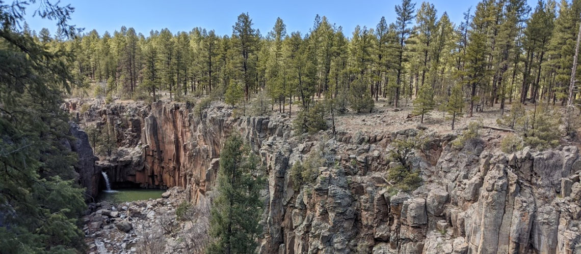
I found this one on a list of Top Underrated Spots in Arizona. Sycamore Falls is also known as Paradise Forks and is located in the Kaibab National Forest near Williams, AZ.
This location had been on my list for quite a while but it hadn’t rained the entire time we’d been in Arizona (about a month); the waterfalls don’t always flow and are best to visit after a decent rain or during certain times in the spring when there is plenty of snow melt runoff from the mountains. We had a good, heavy rain all weekend and I knew it’d be our best opportunity.
The trailhead leads to the 21-mile long Sycamore Canyon. Paradise Forks is named for where the canyon forks to two waterfalls, one to the left and one to the right.
We quickly came upon the first falls on the left.


On our journey in search of the waterfall on the right, we came upon what we later realized was a third, bonus waterfall. Here we found a nice spot close to the edge and commenced one of our new favorite things to do: eat lunch and take in the spectacular scenery.


After lunch, we carried on to the right to find the final waterfall.


After that we decided to wander around the forest for a bit and the dogs got to run around off-leash for a little while.


Side note: do you know if your significant other has a favorite tree? I didn’t either! Until now.
Sean’s favorite tree is a ponderosa pine tree. Its sap smells like butterscotch! This was the perfect hike for Sean, because, to his delight, the falls happen to be situated in the midst of a forest of tall ponderosa pines.


Finally we cut across the river (Bruno’s belly got very wet) to get a view of the falls from the other side as well.


Baldwin Trail for views of Cathedral Rock at sunset

We usually try to hike in the morning when it’s cooler and there are fewer people, but I had read that there are stunning views of Cathedral Rock at sunset.
So late one afternoon we went to Baldwin Trail which is supposed to intersect with Red Rock Crossing. We couldn’t quite figure out exactly where we were supposed to be, and I think we were meant to cross a stream… but we found a a nice spot along Baldwin Trail instead.

When the sun sets, the light on Cathedral Rock turns it a bright orange.

Doe Mountain

Doe Mountain Trail is a short 1.5-mile hike with several switchbacks leading to a large mesa (flat-topped mountain). The trek up required a few basset-butt-lifts, but the top was nice and flat with plenty of overhangs and mountain views.


We continued our walk around the top of the mesa for another mile or so, taking in the different sights at each edge.

Bear Mountain

After we climbed back down Doe Mountain, we made our way right across the road to Bear Mountain. It’s been heating up lately in Arizona and the dogs didn’t seem up for another 5 miles of hiking, so we figured we would just hike up a little ways.

The path up to Bear Mountain was filled with zillions of pale green and purple wildflowers. It conjured desires to frolic in the fields like Maria from the Sound of Music. I sing “Doe, a deer, a female deer. Ray, a drop of golden sun…” a lot these days. Ask Sean. He loves it.
When we started climbing up Bear Mountain, Bruno stopped to pee in every shady spot, making it apparent that he was about done hiking for the day. We made it up to a small overhang for a break with a view.


Interactive photo – click a drag to look around:
On the way back down Bear Mountain, Bruno had had enough of jumping down the red rocks and laid down for another rest.


Copper Canyon

Copper Canyon Loop Trail is 3.9 miles and conveniently located in Camp Verde, AZ, less than 15 minutes away from where we’re staying. It is ironically one of the few hikes we’ve taken without any iconic copper colored rocks.

It was a very hot day. We followed 3 horseback-riders onto the trail and set out to find a supposed waterfall that was said to be a short diversion off the main trail. On our hunt, we took a wrong turn up a steep incline.
Here we experienced something commonly referenced in basset hound folklore: Bruno went “flat basset” for the first time. (I.e. he found a bit of shade and laid down flat, refusing to go any further.) And so we decided to take a little break!
Eventually Bruno mustered the strength to forge onward, and we set out again to find the elusive waterfall. Finally we found a stream, the dogs took a dip to cool off, and we knew we must be getting close.

We finally found it! It was much smaller than the Sycamore Falls, but it was fun to climb up.


In other news, we finished our review of MIT’s beginners’ Python coding course. If you’re interested, here’s the new and improved version of the course: Introduction to Computer Science and Programming Using Python. It’s free to “audit.”
While I’ve been blogging, Sean’s been building a remote temperature monitor using Raspberry Pi (and coding in Python). So far, we’ve only really been doing dog-friendly hikes, but in the future we may do some hikes that dogs aren’t allowed on. Sean’s temperature monitor would allow us to leave the dogs in the RV and alert us if it rose to an unsafe temperature (i.e. if the AC breaks or power shuts off while we’re gone).
Sean will be running a virtual 10K this Saturday, so he’s been running most days between hikes. Running in the miserable heat isn’t my cup of tea (I do workout videos inside the RV instead), but I will be drinking mimosas at the virtual award ceremony/ happy hour afterwards as a show of support.
Less than a week left here, then we’ll be moving north toward Utah!
PS: It takes some time to put together these blog posts, so if just can’t wait and want a sneak peak of our adventures, you can follow me on Instagram @chelsea.i
Love reading these posts, Chels! Nothing like seeing the beautiful scenery of all your guys’ adventures while stuck in quarantine. Also your witty commentary has me LOLing. You’ll have to tell me if/when you guys come through Colorado – hopefully by then things will be back to normal enough to grab a beer! 🙂
Sean’s favorite tree pic 🤣🤣🤣🤣
Bruno’s a model on those red rocks!
Indeed–I found out about Curtis’ favorite tree within a few months of meeting him. I’ve never caught him sniffing one though. 🤣 Loved all of the waterfalls but especially love the Bruno Bunny shot! Good luck to Sean on his virtual run this weekend.